Photo: Screenshot 2026-03-05 at 6.54.51 PM
Rethinking intersection intelligence: building the digital tapestry of urban mobility
06 March 2026
Local governments around the world are under increasing pressure to make streets safer, more efficient, and more adaptive to evolving mobility patterns. From Vision Zero commitments to congestion mitigation mandates, transportation leaders are being asked to deliver measurable results, often within constrained budgets and legacy infrastructure environments.
At the centre of this transformation is a fundamental shift: moving from presence detection to true intersection intelligence and more broadly, toward digitising the physical world.
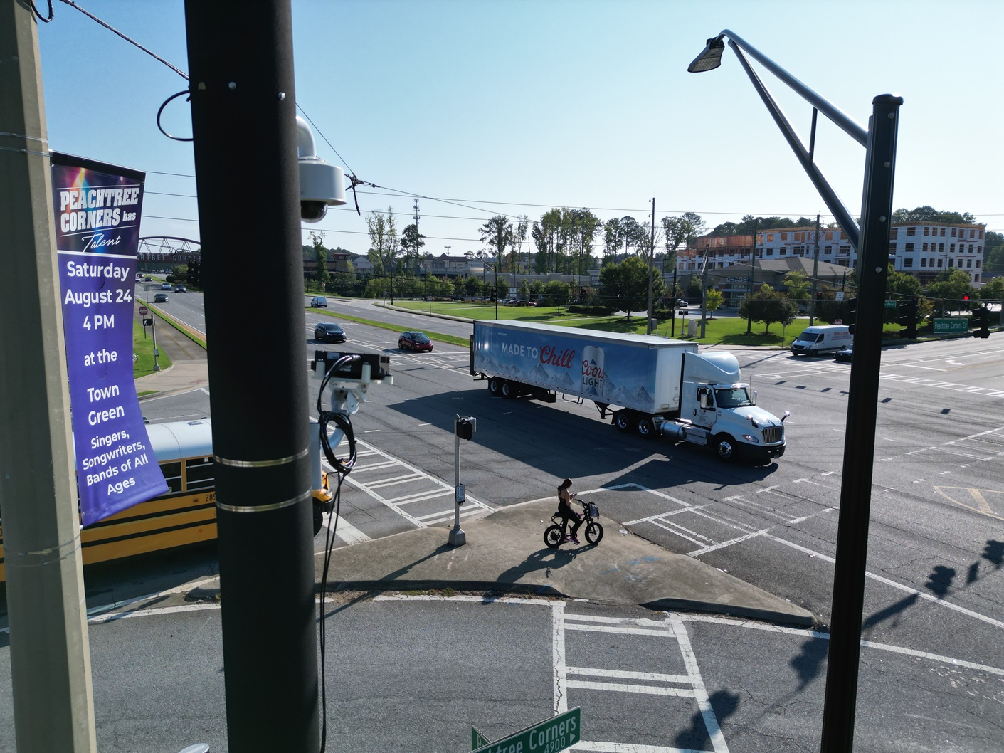
For decades, traffic infrastructure has relied on loops, radar, and camera-based systems to detect vehicles. While these technologies have served cities well, they were designed for a different era, one where simple actuation and basic counting were sufficient. Today, agencies require richer, real-time data that supports safety analytics, multimodal detection, signal optimization, and long-term planning.
Seyond’s SIMPL platform represents this next generation of intelligent sensing.
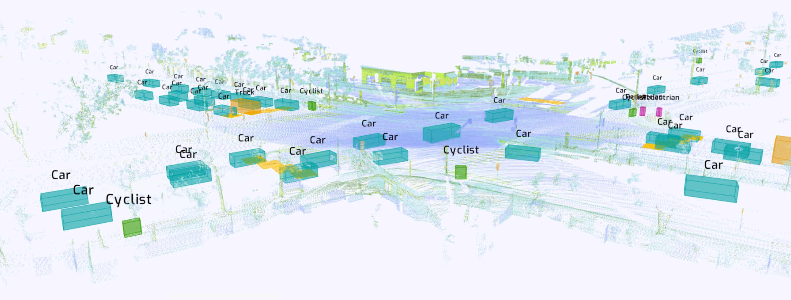
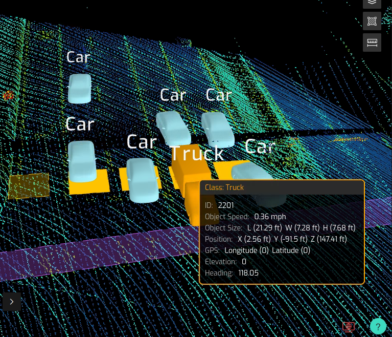
SIMPL leverages high-resolution LiDAR to deliver object-level data, detecting not just that something is present, but what it is, how it is moving, and how it interacts with its environment. Vehicles, pedestrians, cyclists, and micro-mobility users can be identified, classified, and tracked in real time. This contextual awareness fundamentally changes how intersections can operate.

“Cities are no longer asking whether they can detect vehicles,” says Austin Wilson, Head of North America – ITS at Seyond. “They’re asking whether they can understand what’s happening at the intersection, in real time, and use that intelligence to improve safety and performance.”
Beyond operational efficiency, there is a larger strategic implication. When cities deploy advanced sensing infrastructure, they begin weaving a digital tapestry across the built environment, stitching together movement patterns, behaviours, and interactions into structured, usable data.
Digitising the physical world means transforming roads and intersections into dynamic data assets. Instead of static infrastructure, agencies gain a living layer of intelligence that reflects how their cities truly move. This enables planners and policymakers to shift from reactive reporting to continuous insight.
Unlike traditional detection and data collection systems, LiDAR does not rely on ambient light and does not capture personally identifiable imagery. This provides a privacy-forward approach while maintaining high accuracy across challenging weather and lighting conditions, a key consideration for public-sector deployments.
However, hardware alone is not the innovation.
SIMPL is designed as a system-level platform that integrates directly with traffic controllers and broader ITS ecosystems. By delivering edge-processed, structured data into existing signal environments, agencies can deploy advanced detection without overhauling their infrastructure stack. This lowers the barrier to modernisation and enables incremental adoption, critical for scalable public programmes.
One of the most significant shifts enabled by LiDAR-based systems is the ability to move from reactive to proactive safety strategies. Instead of analysing incidents only after they occur, agencies can monitor red light running, near-miss events, and abnormal vehicle behaviour in real time. These leading indicators form the foundation of surrogate safety analysis, a methodology that evaluates risk using measurable conflict metrics such as time-to-collision, post-encroachment time, and trajectory overlap. By identifying patterns of dangerous interactions before they result in crashes, cities can adjust signal timing, refine phasing, or redesign geometry based on predictive evidence rather than waiting for injury statistics.
 “Vision Zero initiatives require more than policy statements,” Wilson adds. “They require data that is granular, trustworthy, and actionable. When you can see speed, trajectory, classification, and object-level interactions, you can design interventions based on evidence, not assumptions.”
Global cities are also preparing for connected and automated mobility ecosystems. As roadside infrastructure becomes a digital partner in mobility networks, the quality of sensing becomes mission-critical. High-resolution object data can support future V2X applications, digital twin modelling, and AI-driven traffic optimisation strategies.
Equally important is deployment practicality. Modern ITS programmes must balance innovation with procurement realities, compliance standards, and long-term maintainability. Scalable architectures and modular edge processing are increasingly central to long-term adoption strategies.
The future of urban mobility will not be defined by any single sensor type. It will be defined by systems that provide reliable, privacy-conscious, and interoperable intelligence at scale, systems that help cities digitise their physical infrastructure and transform it into a connected network.
As Wilson summarises: “Intersection intelligence isn’t just about technology. It’s about giving cities the clarity they need to make better decisions, faster. When we digitise the physical world responsibly, we create a digital foundation that cities can build on for decades.”
In an era where safety, sustainability, and efficiency are intertwined, that digital foundation may prove to be one of the most valuable assets cities can deploy.