
Six US DOTs pilot connected vehicle data for safer hurricane evacuation
15 October 2020
by Sarah Wray
In a new proof-of-concept, the Departments of Transportation of Alabama, Florida, Georgia, North Carolina, Tennessee and Virginia will use connected vehicle data to help monitor and manage emergency evacuations during the hurricane season.
The initiative will use data from Wejo and its network of connected vehicles as people are evacuating to get out of the path of an approaching hurricane. Other partners in the project are database technology company Moonshadow Mobile and the Eastern Transportation Coalition, which is a partnership of 17 states and the District of Columbia focused on connecting public agencies across modes of travel to increase safety and efficiency.
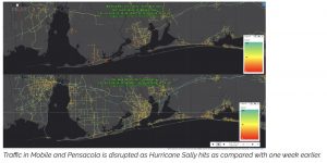
During an evacuation, one of the biggest problems for traffic managers is how to avoid congestion on major escape routes. With the live traffic data system, traffic management centres will have up-to-date information on speeds and congestion from hundreds of thousands of driving vehicles within minutes.
They will be able to see when traffic is becoming congested and where they need to implement lane direction reversals to increase capacity. The system shows which alternate routes are still moving well and how traffic should be redirected. Playing back movement over time will also provide insights into when and where the public is evacuating.
Missing piece
Wejo collects data from over 18 million active vehicles in the United States and says it has close to 100 percent road coverage. Moonshadow receives 95 percent of the data from Wejo within 60 seconds of it leaving the vehicle and ingests it into Moonshadow Live Traffic, an online service based on Moonshadow’s DB4IoT connected vehicle database engine. The project has created scaling factors that aggregate the street mapping data every 30 minutes for each day of the week for every road segment. Moonshadow will use the scaling factors to estimate the total amount of traffic on each road segment at any point in time.
The system shows speeds and volume estimates for the entire region within five minutes of real-time. It could be used during events such as hurricanes, fires, flooding or other natural disasters.
“I am very excited to bring this ground-breaking work to our member states. Real time volumes are the most important piece of missing data that agencies need today, especially when monitoring severe weather events such as hurricanes,” said Patricia Hendren, Executive Director of the Eastern Transportation Coalition. “Currently, transportation agencies must rely on archived, historical data to make real-time operational decisions. Data from vehicles is the future and the coalition is committed to pushing the innovation barrier to bring agencies critical information especially when it comes to cross-border movements.”