MTA to trial app that guides visually impaired passengers
29 October 2020
by Christopher Carey
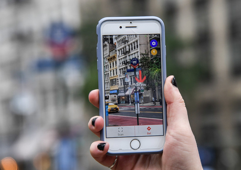
New York’s Metropolitan Transportation Authority (MTA) and the Transit Innovation Partnership have launched a pilot scheme that allows blind and low-vision bus riders to use their smartphones to locate bus stops and learn of arrival times.
The NaviLens app, which can be downloaded on Android or iOS devices, uses an algorithm to translate visual signage into audio and allows customers to determine accurate locations and distances to the nearest bus stop, find out when the next bus will arrive, know how crowded the bus is (if the necessary sensor technology is onboard) and be directed onto the bus when it pulls up to the stop.
Craig Cipriano, President of MTA, Bus said: “Accessibility is a key priority for the bus system and MTA family, and this app pilot is another way to help bus riders who rely on audio cues and signals to guide them.”
Colourful QR codes are installed on bus stop poles that the app can detect from up to 12 metres away and at an angle of up to 160 degrees.
The code does not have to be in focus for app detection, and will direct the user by providing audio directional cues including distance and angle from code, solving ‘last-few-yards’ wayfinding problems for the blind where GPS technology does not guide to a destination’s exact location.
Transit Tech Lab
Spanish-based firm NaviLens was one of nine startups selected as part of the 2020 Transit Tech Lab, an accelerator programme that calls on innovative firms to solve public transportation challenges in New York City.
The lab is part of the Transit Innovation Partnership, a public-private initiative created by the MTA and Partnership for New York City in response to New York Governor Andrew Cuomo’s call for private sector innovation to improve and modernise public transit.
Along with NaviLens, eight other startups took part in the 2020 edition of the Lab:
- Acoustic Protocol: Converts audio public address announcements into personalised, targeted messages to improve accessibility for deaf and hard of hearing customers.
- Knaq: Provides predictive elevator and escalator maintenance tools enabling any service elevator to be digitised and its status instantly updated online.
- Allvision IO: Inventories kerb infrastructure and monitors street parking behaviour of both commercial and non-commercial vehicles.
- CARMERA: Provides up-to-the-minute construction data and descriptions, such as obstructions in parking spots or traffic lanes.
- CurbFlow: Marketplace for kerbside access that sources dedicated kerb supply from municipalities to create pickup and drop-off management and maps.
- Numina: Measures kerb-level behaviours using a proprietary, camera-based sensor that mounts to any fixed infrastructure. Numina processes all imagery securely onboard the sensor, anonymously measures activity and provides behavioural insights to improve traffic operations.
- Miles: Provides anonymised multimodal analytics to cities and offers mileage-based rewards to users encouraging public transit use.
- Okeenea: Smartphone app that provides transit system navigation for customers who are blind/low vision or deaf/hard of hearing.