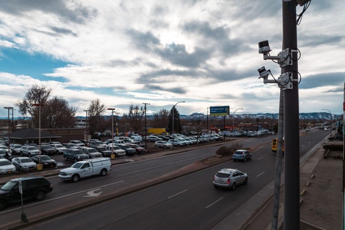
Photo: Ouster – Traffic analytics using digital lidar in Colorado
Making our cities smarter and safer with lidar sensors
19 April 2023
US Transportation Secretary Pete Buttigieg has called traffic deaths “a national crisis on our roadways,” and said collective action is needed across the board to address this.
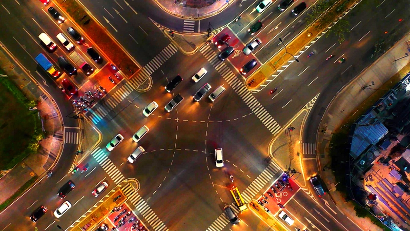
According to the National Highway Traffic Safety Administration, an estimated 31,785 people died in traffic crashes in the US in the first nine months of 2022 – and deaths among vulnerable road users such as cyclists and pedestrians continued to rise. There are over 10,000 fatalities at intersections in the US each year.
Reducing traffic deaths and related injuries requires innovative technologies and approaches. The Advanced Research Projects Agency for Infrastructure (ARPA-I) within the US Department of Transportation has identified lidar as one such innovative technology that can help solve key gaps in America’s transportation and infrastructure. Now, through multiple grant programmes under the Bipartisan Infrastructure Law, cities and states can receive federal funding to deploy lidar as part of their strategies to make cities smarter and safer.
Itai Dadon, VP of Smart Infrastructure at Ouster, noted that lidar sensors can provide cities with high quality data they can’t get in other ways to inform road safety strategies and save lives. He was speaking at the recent Cities Today Institute City Leadership Forum in Las Vegas.
Ouster is one of the leading lidar manufacturers and solution providers globally, and part of its business is focused squarely on smart infrastructure, working with city and state transportation departments in the US and beyond.
As governments look to implement strategies to improve roadway safety, they are looking at new ways to make evidence-based decisions.
“It’s really all about the data,” said Dadon. “And to get the right data, you really need to look at the world with the right technology and the right sensors.”
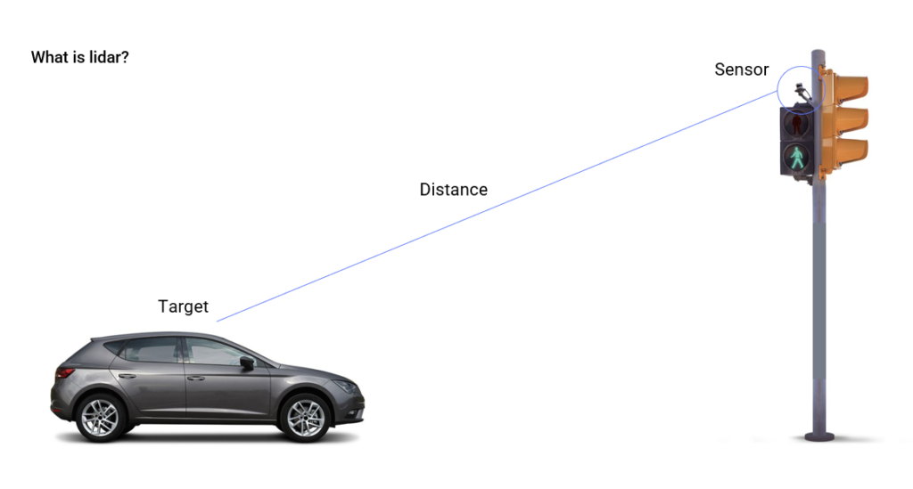
Lidar explained
Lidar sensors mounted on poles or streetlights send out eye-safe laser beams and measure the reflections coming back from objects. The length of time between the laser beams being sent and bouncing back provides information about where objects are in space to a high-level of accuracy – down to the centimetre or millimetre.
Dadon explained: “The result is, unlike video where you have just an x and y coordinate for your pixels, you have what we call a ‘point cloud’. It’s a set of points in space that effectively gives you a three-dimensional view of your infrastructure and everything around it.”
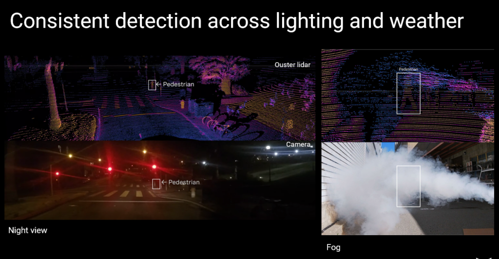
Night vision
One of the key benefits of lidar in terms of road safety is its ability to ‘see’ vehicles, pedestrians, bikes, scooters and other objects clearly in low-light conditions, at night, and in inclement weather such as fog or rain – conditions where cameras often struggle to provide reliable data.
“Most of the technology that we have today on the roads is not well equipped to see pedestrians and other vulnerable road users in low visibility situations,” said Dadon.
This is important when you take into account that almost half of vehicle occupant fatalities happen at night, despite only 25 percent of travel taking place after dark. Most pedestrian fatalities also occur at night.
Reliable, real-time data for informed decisions
In a variety of road safety situations, lidar allows for near-miss analysis to understand exactly what happened and how it can be avoided in the future. Vehicles, pedestrians and other moving objects can also be accurately classified to provide more information about potential incidents and road usage.
The technology can also monitor signal performance, red-light running, and jaywalking.
This data then informs interventions such as speed reduction measures or the best placement of crosswalks.
For instance, the City of Irvine, CA, in collaboration with a local university, is focused on reducing near-miss events and cutting carbon emissions. They’re successfully using lidar to drive signal time changes and other efficiencies, said Brian Garrett, a sales director for Ouster’s smart infrastructure business.
Meanwhile, a project at one of the most dangerous corridors in Lakewood, Colorado (in terms of pedestrian fatalities) is detecting pedestrians walking across the road outside of the crosswalk. This data is not only used to justify new signal timing and pedestrian amenities, but will be activating beacons and real-time variable messaging signage (VMS) to warn oncoming road traffic that someone is walking.
“So not only are we driving insights to make those future changes, we’re also making a real-time difference,” said Garrett.
Demand for lidar is growing. According to Grand View Research, the global lidar market was valued at US$1.8 billion in 2021 and is expected to expand at a compound annual growth rate of 9.8 percent to reach US$4.7 billion by 2030.
As well as a rising need for 3D imagery, privacy is another driver, said Dadon. Cameras often raise surveillance concerns, whereas lidar is privacy-preserving.
“Lidar is completely deprived of any personally identifiable information,” he explained. “There is no way of knowing who the people walking in a place are. And it’s also completely independent of any bias related to skin tone, unlike some other computer vision algorithms.”
Garrett added that falling costs mean cities can put multiple lidar sensors up and ‘stitch’ them together to see full corridors and even create a digital twin of the environment, which is useful for traffic management centres.