Photo: Horst Petzold | Dreamstime.com
How the City of Hamilton transformed its air quality with active monitoring
01 November 2023
Nestled on the shores of Lake Ontario, the City of Hamilton is a goods movement gateway between Southern Ontario and international markets.
The Canadian city includes corridors made up of rail lines, highways, ports, rail yards and an airport. Almost all goods consumed by residents, and in the supply chain process, arrive by trucks. Because of this there is a designated truck route network to strike a balance between industry and community needs.

“For trucks to access certain portions of the highway, the quickest route has been through partially residential areas and the downtown,” says Cyrus Tehrani, Chief Digital Officer at the city.
A project was launched to evaluate the current truck route and to identify possible alternatives. Despite being predominantly a transport planning project, air quality was a major factor taken into consideration. Although the city does have some existing fixed air quality devices, it needed a broader range of detectors to give a more holistic picture.
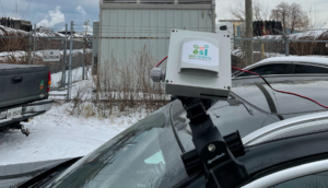
“We used mobile devices provided by Ecosystem Informatics Inc [ESI],” says Tehrani. “We were able to do a before and after analysis of localised air quality – firstly for the existing truck network, and then for other alternative routes.”
Real-time data
This gave the city access to valuable data and visualisations to help understand the impact on air quality in areas that were no longer part of the truck route, as well as how the shift to the new routes resulted in potential changes in air quality.
“This was one of the first times we’d really leveraged mobile air quality monitoring to get real-time data analytics that supported a quicker way of capturing quality data from a broad area to inform decision-making at the city level,” says Tehrani.
The AI-powered devices, weighing just 1kg, can house up to eight different gas sensors in the same unit and consume little energy. The data is provided in real time where each data point has geolocation information attached to it.

“We are the only company that could put this device on any vehicle and be able to collect data accurately without the need for any special platform, special technician or any change in infrastructure to enable it,” explains Shirook Ali, CEO and Founder of ESI. “It is just a simple add-on to the current infrastructure with which you can get an abundance of data.”
Alby Bocanegra, former Chief Technology Officer for New York City, knows how important that “plug and play” aspect is to leaders in major cities across the world.
“I’m not a big fan of putting more furniture on the streets, and I saw that the ESI sensors are small enough to be attached to municipal-owned fleets, and even static infrastructure,” says Bocanegra, who currently serves as Chief Future Officer and Founder at The Urban Futurist. He is also an advisor to ESI.
“Having very accurate and hyperlocal data on air quality can really allow cities to move the needle on public health.”
Measure it to manage it

According to the World Health Organization, air pollution is one of the most significant environmental risks to health, with 91 percent of people living in cities breathing polluted air. Poor air quality causes 6.7 million premature deaths annually and increases chronic disease burden, disproportionately impacting marginalised and vulnerable communities.
Iyad Kheirbek, Director of Air Quality at climate action network C40 Cities, says for policymakers to act, they first need the evidence.
“You can’t really manage air pollution unless you know what the air quality levels are now, what air quality levels you want to get to and how to get there,” he says. “And then, how do you know that you’ve gotten there? And how do you demonstrate the progress that you’re making?”
He believes it is essential that environment departments work closely with public health departments to better understand the public health impacts of air pollution. This needs to happen alongside a wider conversation and show that air pollution is an important linkage across all agendas including climate, air quality, health and equity.
Neighbourhood information
While most European and North American cities are installing more air quality measuring devices, understanding how air pollution differs from one neighbourhood to another, on the micro level, is the next step.
Ali says that ESI devices can already achieve this and are only just “scratching the surface” in terms of use cases and how they can be applied to help cities better plan and understand their urban environments.
By using predictive analysis from the data, the potential is almost endless, she says – with applications including operational efficiencies, sustainability and climate initiatives, health and safety, and risk management. The data can then be validated or quantified from benchmarking before and after interventions are implemented.
“We can have all sorts of intelligent alert systems that could trigger action much faster than traditional methods,” Ali adds. “Our focus is on informing cities about the availability of such data but at a practical cost. The quantity of data our devices can obtain would be very cost-prohibitive using traditional techniques.”
Tehrani believes that in the past cities would have been stuck in more traditional ways of thinking, meaning it was either “fixed station deployments or nothing”.
“But now [ESI devices] open up opportunities in the future for when there are use cases for mobile deployments or when you need a quicker deployment, or even a temporary deployment. We know now that that opportunity exists.”
Learn more about ESI at Booth B71-P1 at the Smart City Expo World Congress in Barcelona (November 7-9, 2023)
ESI devices can be used to support:
- Air quality measurement
Real-time data measurement and analytics help cities identify and mitigate critical air quality areas.
- Infrastructure planning
Data and modelling assist municipalities in planning for future scenarios and growth.
One example would be understanding the impact of road expansion on emission levels.
- Transport planning
Scenario modelling and real-time/historical data aid cities to reach better outcomes in transport planning.
And can provide:
- Hyperlocal monitoring
Capture data at a block-by-block, area-by-area, city-by-city level.
- High-resolution heat maps
Impactful visualisation so that you get a complete picture of air quality.
- Extremely scalable
Sampling devices can be configured to be stationary or mobile and easily scaled from small single nodes to large grids for measuring across large areas.
Brought to you in partnership with:
![]()