
Photo: Noralí Nayla on Unsplash
From data to action: How citizen engagement enables inclusive mobility solutions
10 May 2023
City planning that encourages residents to walk, cycle, and wheel is crucial for public health, environmental well-being, and overall quality of life. But how can we make active travel a more attractive choice for everyone?
The answer lies in citizen engagement. When locals and stakeholders participate in the planning process, their input shapes solutions that address real pain points and support their mobility choices.
Let’s zoom in on how two different cities – St Andrews and Copenhagen – employ citizen engagement for the benefit of locals and planners. In both cases, local insights collected during digital public consultations shaped the infrastructure to alleviate barriers and encourage more sustainable and active mobility choices.
Active travel: Lessons from St Andrews
St Andrews in Scotland, a small town of around 18,000 people, sees a massive influx of tourists each year due to its prestigious university, scenic beaches, and famous golf course. However, the town’s current infrastructure does not support active travel. The Active Way project is there to change the situation: this community-led initiative aims to make cycling, walking, and wheeling a safe and enjoyable option for locals and visitors alike.
The project conducted two public consultations, with the first traditional survey gauging local attitudes towards active mobility and low-traffic neighborhoods. However, this survey did not provide insights into how and why people move through the town’s built environment.
To understand the spatial component better, the second consultation used Maptionnaire, a map-based citizen engagement platform, allowing residents to pinpoint favorite public spaces, problematic areas, and routes taken or avoided. This data was then used to inform the design of a new route proposal.
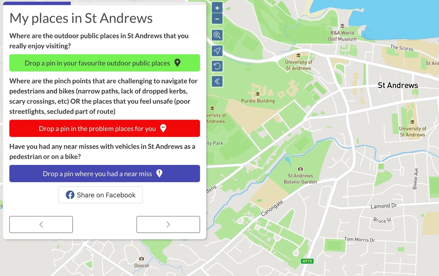
For example, the locals marked over 600 favorite outdoor places in St Andrews on a digital map, these places being primarily clustered around green areas in the inner city and along the coast. This information will help the Active Way project and their consultant The Cycle Path determine where changes should take place to encourage active travel.
By continuously involving residents at all stages of the planning process, the Active Way project created a blueprint for future public consultations in planning. This engagement enabled the design of infrastructure and mobility solutions that promote active travel, leading to environmental well-being, safety, and happier lives for everyone.
Building EV charging infrastructure: Lessons from Copenhagen
In a similar way, to accelerate the switch to electric and hybrid vehicles, the supportive infrastructure must reflect local preferences and habits. And what better way to gather this information than simply asking users where they would like charging stations to be located?
The City of Copenhagen – home to 600,000 residents, rising to more than 2 million in the metropolitan area – consulted its residents, stakeholders, and guests when expanding its EV charging infrastructure. By running the consultation with a digital platform, the planners ensured a broad outreach and gathered precise data to support the development work.
For this project, the Construction, Parking, and Environment Office designed a Maptionnaire survey where respondents simply marked on a digital map the desired location for a charging station. The map also shows the existing charger infrastructure, helping respondents make a more balanced decision.
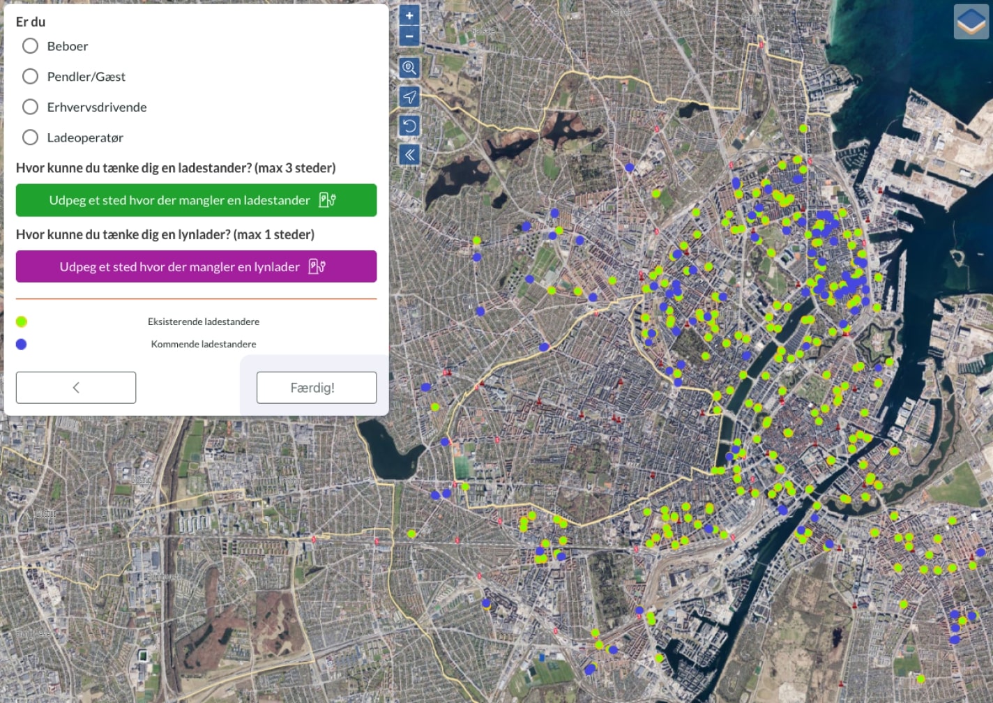
On the next page, respondents selected a group to which they belong: resident, tourist, business owner, or stakeholder (e.g., electric charger provider). This way, planners evaluated the needs for charging infrastructure for each group of respondents, making the approach more nuanced.
What’s more, the planners get the results as geolocated data – their bread and butter – directly from residents’ input. By taking into account the preferences and habits of local users, they were able to design a more efficient and effective infrastructure that meets the needs of all stakeholders.
Bringing citizens to the centre of planning
People are at the heart of mobility and transportation solutions – and they should be at the center of the planning process too. As the examples above have shown, digital citizen engagement tools enable this process to be inclusive, democratic, and impactful.
The citizen-generated data obtained in the engagement process complements other GIS datasets and helps planners to identify where, how, and why people move through spaces. Eventually, citizen engagement leads to more citizen-centered and inclusive mobility solutions.
To understand better how to use citizen engagement platforms like Maptionnaire for collecting data about citizen behaviour, habits, and barriers to mobility – and to replicate best practices of successful engagement projects of various scales – join our free webinar on citizen engagement for sustainable mobility and transportation planning. You’ll hear from Dr. Ariane Scheffer, Project Manager for Traffic and Mobility at Luxplan, and Hannu Stewart, Head of Sales at Maptionnaire. The webinar is on May 25, 2023, at 13.00 GMT+1, and you can join online or watch it on demand later.
Photo credit/caption: Noralí Nayla on Unsplash