Photo: City of Helsinki
Helsinki launches real-time crowding heatmap
23 June 2021
by Sarah Wray

Photo: City of Helsinki
23 June 2021
by Sarah Wray
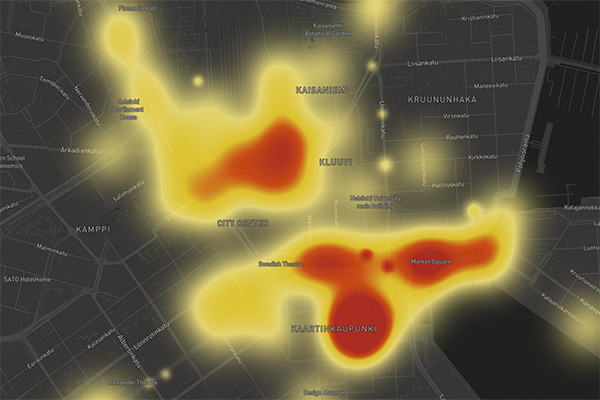
The City of Helsinki's new Heatmap site shows how busy areas and venues are in real-time to help people plan trips while avoiding crowded areas.
The project aims to improve safety, support the tourism industry and deliver new data for the city.
A colour-coded map, which is updated every minute, has been developed with software company Hypercell, and the city is installing sensors in the centre and other popular tourist areas to detect anonymous Bluetooth signals from devices such as mobile phones.
The signals measure crowd volume, the average time people spend in specific locations, and the movement of crowds within the sensor network.
The trend for tracking busyness in cities vi...
Unregistered users have limited access to our stories. Register for free now to enjoy Cities Today without restrictions.
Already a subscriber?
| Cookie | Duration | Description |
|---|---|---|
| cookielawinfo-checbox-analytics | 11 months | This cookie is set by GDPR Cookie Consent plugin. The cookie is used to store the user consent for the cookies in the category "Analytics". |
| cookielawinfo-checbox-functional | 11 months | The cookie is set by GDPR cookie consent to record the user consent for the cookies in the category "Functional". |
| cookielawinfo-checbox-others | 11 months | This cookie is set by GDPR Cookie Consent plugin. The cookie is used to store the user consent for the cookies in the category "Other. |
| cookielawinfo-checkbox-necessary | 11 months | This cookie is set by GDPR Cookie Consent plugin. The cookies is used to store the user consent for the cookies in the category "Necessary". |
| cookielawinfo-checkbox-performance | 11 months | This cookie is set by GDPR Cookie Consent plugin. The cookie is used to store the user consent for the cookies in the category "Performance". |
| viewed_cookie_policy | 11 months | The cookie is set by the GDPR Cookie Consent plugin and is used to store whether or not user has consented to the use of cookies. It does not store any personal data. |
You have reached the limit for the basic subscription. Please upgrade to Premium to download more
You have reached the limit for the basic subscription. Please upgrade to Premium to save more

