Photo: Image: Smart Christchurch
Sensors boost earthquake resilience in Christchurch
17 June 2020
by Sarah Wray
Christchurch City Council in New Zealand is exploring new ways to use the data from its EQRNet earthquake response management system, which was recently named as the winner in the Public Safety – Disaster Response/Emergency Management category of the IDC Smart City Asia Pacific Awards.
In July 2018, the Smart Christchurch programme at Christchurch City Council initiated a three-year trial of EQRNet with local company Canterbury Seismic Instruments (CSI).
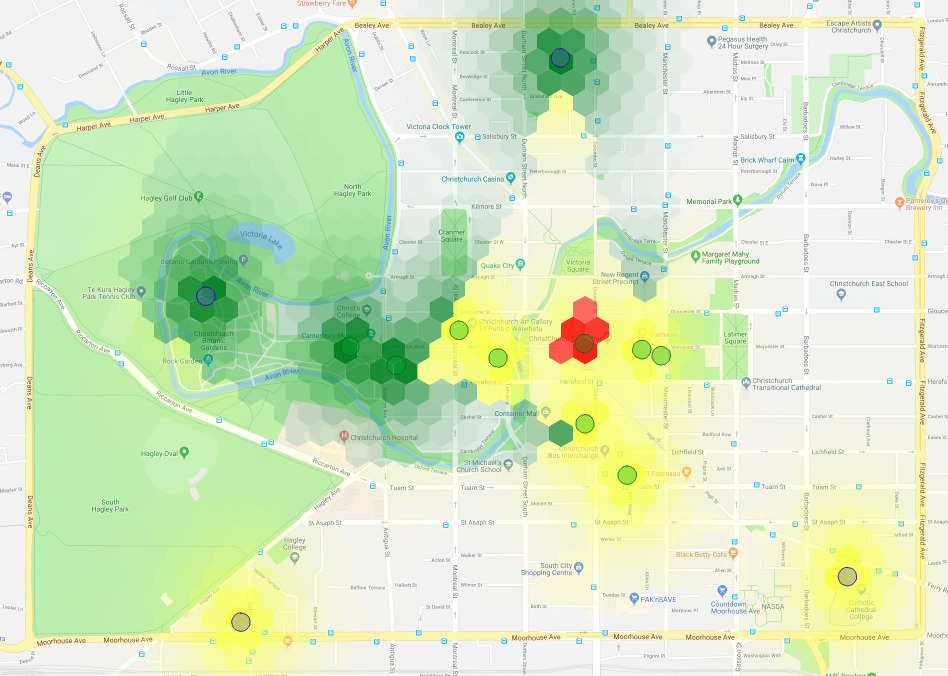
EQRNet is a dense network of more than 150 ground-based accelerometers which allows the council to better manage its earthquake response using real-time information. The trial was initiated following a ten-sensor pilot in Christchurch which demonstrated significant variations in ground-shaking over distances as small as 100 metres, showing that a much greater level of monitoring than that available from existing GeoNet instrumentation could be beneficial.
Most of the sensors are installed in traffic signal boxes as well as at council facilities and other key sites.
Grace de Leon, Smart Christchurch Project Manager, told Cities Today: “There is significant variation in the ground shaking over small distances and this translates to variable damage to buildings and infrastructure. We need more detailed and localised information about the effects of earthquakes to best manage our response.”
By comparing the intensity of localised shaking to building code information EQRNet can provide rapid assessments of potential structural damage. The network’s output provides real-time information to building managers, emergency teams and the public, allowing them to make fast decisions about evacuation.
Situational awareness
De Leon said the biggest takeaway from the EQRNet project so far is that: “Earthquake effects can be measured and better situational awareness is possible – from city-wide infrastructure such as water networks right down to an individual building level. It is not difficult and the cost-benefit ratio is compelling.”
“A major benefit for the Christchurch City Council is a much better understanding and approach to the re-occupancy of our buildings following an earthquake event. We can occupy more quickly following a risk-based approach and our use of engineers is much more targeted and cost-effective,” she said.
With the network in place, the Smart Christchurch team is in discussions with wider groups within the council as to how they can best make use of the information from the system, de Leon said.
This could include using network maps overlaid onto maps of peak ground movement/displacement to show areas of likely damage to road and underground assets, and overlaying liquefaction vulnerability maps with peak acceleration and roading maps to show roads and access routes which may be impassable or where water and other services could be interrupted. Further, the information could help pinpoint which council-owned buildings could best be used as welfare centres or other essential services which could remain open in the event of an earthquake.
There are now plans to potentially expand the networks throughout New Zealand and overseas as well as to a broader range of stakeholders.
A series of major earthquakes and aftershocks hit the Canterbury region between 2010 and the end of 2011. Christchurch City Council says that the recent impacts of earthquakes in Canterbury, Marlborough and Wellington have caused economic losses of NZ$50 billion (US$32.3 billion) on top of major loss of life. This, the council notes, as well as the growing prevalence of risk-based insurance premiums, make it a requirement for local and central government agencies and emergency response teams to capture a greater amount of quality information for “defensible decision-making” using systems such as EQRNet.