Photo: MIT CSAIL
AI model can ‘predict’ traffic accidents before they occur
20 October 2021
by Christopher Carey
Researchers from MIT’s Computer Science and Artificial Intelligence Laboratory (CSAIL) and the Qatar Center for Artificial Intelligence have developed a ‘deep learning’ AI model capable of predicting traffic patterns with high-resolution risk maps.
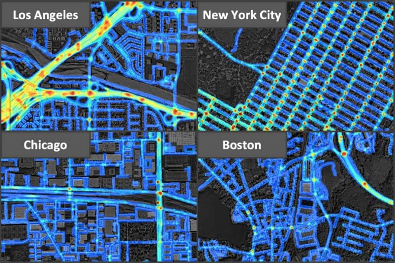
Using road maps, satellite imagery and GPS traces, the risk maps describe the expected number of crashes over a period of time in the future, to identify high-risk areas and predict crashes.
“By capturing the underlying risk distribution that determines the probability of future crashes at all places, and without any historical data, we can find safer routes, enable auto insurance companies to provide customised insurance plans based on driving trajectories of customers, help city planners design safer roads, and even predict future crashes,” said MIT CSAIL PhD student Songtao He, lead author of the study.
Researchers based their dataset on occurrences within an area of more than 7,500 square kilometres from Los Angeles, New York City, Chicago and Boston.
Among those four cities, the data suggests that LA was the most unsafe and suffered the highest crash density, while Boston had the lowest.
Granular detail
Before now, risk maps could only collect data points over areas in the hundreds of metres. The new maps contain 5×5 metre grid cells to provide more granular detail.
“Our model can generalise from one city to another by combining multiple clues from seemingly unrelated data sources,” said Amin Sadeghi, co-author of the study. “This is a step toward general AI, because our model can predict crash maps in uncharted territories.”
Previous attempts to predict crash risk have been largely “historical,” as an area would only be considered high-risk if there was a previous nearby crash.
The study’s authors said their team’s approach cast a wider net to capture critical data, identifying high-risk locations using GPS trajectory patterns – which give information about density, speed, and direction of traffic – and satellite imagery that describes road structures, such as the number of lanes, whether there’s a shoulder, or if there are a large number of pedestrians.
Then, even if an area has no recorded crashes, it can still be identified as high-risk, based on its traffic patterns and topology alone.
Traffic accidents are the leading cause of death in children and young adults globally, according to the World Health Organization.
Image: MIT CSAIL