Photo: Bernard Spragg. NZ (Flickr)
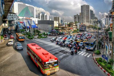
Startup maps Bangkok’s transport network
27 January 2021
by Christopher Carey
London-based mapping company WhereIsMyTransport has completed what it claims is the first comprehensive overview of Bangkok’s transport network, mapping 40,000 kilometres of data across the city in 60 days.
The firm, which specialises in mapping transport data in emerging cities globally, employed a team of 25 locally based data collectors to travel across the Thai capital’s public transit network – including the MRT, the BTS Skytrain and bus services – as well as the vast array of informal ‘songthaew’, minibus and riverboat routes that provide the bulk of first- and last-mile services.
Local staff collected key data on routes and fares which was then uploaded to WhereIsMyTransport’s database at the end of each journey.
Yohnny Raich, Data Product Owner, WhereIsMyTransport, told Cities Today: “We did quite a bit of research before starting our data collection to see if anything like this already existed, and couldn’t find a comprehensive source that provided an up-to-date overview of all transit options across the city.”
Through its research, the firm found that while data on established routes like the MRT and BTS skytrain was publicly available, there were discrepancies in timetables for localised bus services, and a distinct lack of data for the huge range of informal privately operated minibus-type services that complement traditional public transport.
“I think the most interesting finding for us was the size and scale of the city’s transport network – there are over 800 public transportation routes in Bangkok,” said Raich. “We’ve developed our own mobile application that enables us to collect all of the relevant information – the routes, frequencies, hours of operation and approximate fare payments, etc.”
Data collected from the Bangkok project is available for organisations to licence for a fee, and previous clients include the World Bank, which used WhereIsMyTransport’s data to support urban accessibility evaluations in multiple African cities.
Mapping emerging cities
In February, WhereIsMyTransport raised US$7.5 million in a Series A funding round, with investment from companies including Google and Toyota Tsusho Corporation (TTC).
The startup first began mapping cities in Africa in 2015, before expanding to India, Southeast Asia and Latin America.
It is currently focused on bridging the information gap around informal modes of transport like minibuses and rickshaws, which account for a high proportion of urban travel in developing cities globally.
Bangkok is the third emerging ‘megacity’ WhereIsMyTransport has mapped, after Mexico City and Dhaka, and the firm plans to be the first mapping operator to collect a complete set of data on formal and informal public transport in the developing world’s 30 largest cities by 2023.
“The production and maintenance of this mobility data is a fundamental first step towards transforming the public transport experience for hundreds of millions of people, and with it the social, cultural and economic landscape of these cities,” said Devin de Vries, CEO, WhereIsMyTransport.
“We recruit large local teams, train them to use our proprietary suite of tools, and work alongside them to collect data on the public networks that they know better than anybody – this collaborative method means we uncover every nuance in these unique, home-grown transport systems.”
Image: Bernard Spragg NZ (Flickr)