
Photo: How-urban-infrastructure-inventories-can-assist-resilience-planning
How urban infrastructure inventories can assist resilience planning
27 April 2015
by Richard Forster
Climate change can significantly impact the infrastructure of a city, yet different infrastructures are generally managed by various agencies with data often scattered across several departments. Rozita Singh* explores how a new infrastructure inventory is helping Indian cities streamline and coordinate their resilience planning
In Indian cities, there is no centralised repository of information available to the urban local bodies (ULBs). This means that each time a planning activity takes place, the ULB has to collect, update and sometimes re-collect data from several departments. In the absence of a centralised and standardised inventory, city planners and decision makers are not able to conduct risk and vulnerability assessments that are multi-sectoral in nature.
Studies point out that urban infrastructure inventories enable an understanding of the interdependencies between the various sectors, for instance how a failure in one will impact the other. Infrastructure inventories are thus considered important tools for initiating urban climate change resilience planning.
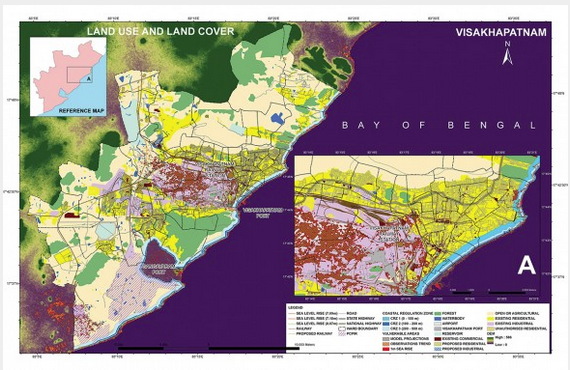
In an effort to address these challenges and demonstrate a centralised data repository, TERI, the New Delhi- based Energy and Resources Institute, has developed an urban infrastructure inventory for two Indian coastal cities–Panaji, Goa and Visakhapatnam, Andhra Pradesh.
This activity was part of a larger assessment conducted over a year as part of the Climate Resilient Infrastructure Services (CRIS) Small Grants Program which is part of USAID’s Climate Change Resilient Development (CCRD) project. This tool allows the city authorities to maintain data through sector wise forms that can be accessed to record, retrieve and update information to support urban development and climate resilience planning efforts. The inventory covers heritage and tourism, water supply, sewerage and drainage, solid waste management, transport, social infrastructure (schools and hospitals), ecologically sensitive areas, energy and telecommunications, disaster management, and climate.
The purpose was to collect baseline information on infrastructure assets and services at the city level and collate all the inter-departmental data at one single place for the municipal corporation which can support urban development and climate resilience planning efforts. The baseline information collected in the pilot cities is already being fed into the Database Management System (DBMS) to provide a broader overview of the data available to them when they plan for climate resilience.
“Being a public body we are very poor in data collection and data is all you need to work and develop a plan for the future,” says Sanjit Rodrigues, Municipal Commissioner of Panaji. “I think the ‘inventorisation’ of both natural and manmade structures will go a long way in building a plan for maintaining these assets for our future.”
The data fields for which data could not be procured, or was not available during the duration of the study, have been left vacant to be later completed by the city government. This was done with a view that these data fields would help the cities to improve their data inventory as well as contextualise it to their needs.
Apart from including the existing data fields maintained by the cities for day-to-day planning activities, the DBMS also provides data fields which are important from a climate resilience planning perspective. These have been colour coded separately within the sectoral forms. For instance, the ward covers details of basic services; location, material used, design capacities, elevation and maintenance activity details for some infrastructure assets. It is recommended that the city maintains a list of locations that are flood prone and are water logged in the city along with their total area on an annual basis. In the case of wastewater, the DBMS allows the recording of information on location and height of outfall points and paved and unpaved areas in storm water zones.
Additionally, in the social infrastructure sector, information pertaining to seasonality of cases can be recorded which includes the number of cases registered and the duration of outbreak for a water borne or vector borne disease. Within the transport sector, the suggested data fields include: the elevation of bridges from a High Tide Level (HTL), and the design height of railway tracks.
The DBMS at present has been developed as a Windows based application, which can be easily installed on a standalone computer. Another important feature of the Database Management System is the Spatial Inventory component. This primarily includes the maps which have been prepared for the two cities in Arc GIS 10 platform and depicts the locations of the various infrastructure assets and service networks. Maps marking the key infrastructure assets have been linked to the DBMS and can be viewed as jpeg files.
To understand the impact of sea level rise on infrastructure assets, several scenarios were also plotted on the digital elevation model (DEM) datasets which were then overlaid on the sector wise maps for the two cities. This led to identification of vulnerable infrastructure in the two cities.
“Sea level rise and the threat to our coasts is a grave issue and climate change has to be considered seriously,” says Manohar Parrikar, Chief Minister of Goa. “Such initiatives can be the beginning of solving such problems. The database will help in mitigating towards possible scenarios and these initiatives can be replicated in the State once they take root in Panaji. Everyone can do something and change the scenario, provided you have the right opportunity, authority and continuous urge for it.”
This inventory is only a starting point and plays an important role in sensitising city officials to the impacts posed by climate change and particularly sea-level rise on coastal cities. The city can now develop this inventory and make it more robust with the help of several departments, TERI has proposed that this inventory be housed at the ULB level and has provided various options for upscaling this knowledge. For instance, this database can be developed into a web-based system providing anytime anywhere access to authorised users so that data from various sources can be fed in using online data entry forms. Department based access rights to specific sectors can also be provided and if the city planning authorities are connected through LAN, this database can be internalised into the day-to-day planning activities of different departments.
In October 2014, TERI organised a national conference on ‘Climate Resilient Coastal Cities’ in New Delhi, with an objective of sharing the outcomes and experiences from the study. The conference focused on generating awareness and initiating dialogue on climate change issues and resilience planning of coastal cities in developing countries. Dr R K Pachauri, Director- General, TERI, in his special video address, highlighted the vulnerability of India’s coastal cities on account of sea-level rise and observed how the increase in frequency and intensity of climate-related extreme events in recent years had caused substantial damage to life and property.
“When somebody comes and applies to build near the coast, we should have enough data to say that these are the risk areas,” says N Yuvaraj, Vice Chairman, Visakhapatnam Urban Development Authority and District Collector, Visakhapatnam. “So TERI’s findings will come as a handy tool as far as this area is concerned.”
*The author is a Research Associate, Centre for Research on Sustainable Urban Development & Transport Systems, Sustainable Habitat Division, TERI. To read the detailed recommendations and access the study documents, see: http://bitly.com/YKhtzO